Greater Manchester Police have just released a new app which uses geo-location technology to allow Mancunians to become crimefighters and to get closer to their local neighbourhood policing teams.
The Apple version of the app was released last month with an Android version promised for Spring.
This review of the new smartphone app produced by Greater Manchester Police was kindly written by @TheCustodySgt
Getting the app
I’m running iOS 6 on an iPhone 4s.
A simple search at the App store for “Greater Manchester Police” and I was soon downloading the app.
It loads quite quickly and popped the GMP crest as a button on my app screen.
A quick check shows that in its current state it takes up 25mb of storage space. Initial view of the landing page is good. It’s clear and uncluttered and in the top right corner is a T&C’s disclaimer.
Features
The whole system is primarily driven by GPS location to tailor information provided to the user.
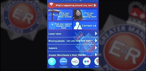
The home page is broken down into two halves. The top half has 5 buttons to access different features.
What’s happening around you now
This is the top end function of the app. Tapping on the red bar, which sometimes takes a couple of attempts, pushes to the new page.
This is the heart of the app that GMP are lauding as the UK’s first location based policing mobile phone app.
Using your phones GPS location ability the app pinpoints your location and then identifies key information near to you. This is laid out on a map with clickable graphics for meetings, missing from home enquiries, wanted persons and appeals.
Clicking on the relevant icon causes the app to slide to an information page with relevant detail and in the case of wanted and missing persons a photograph.
A link to the bottom of the screen allows you to push information directly back to GMP.
In traditional google map style you can change the view between standard map, satellite and hybrid. The map is fully mobile and can be pinched or expanded by the usual finger actions or tapping on the two + & – buttons.
You can also increase your search area by using a radius slider at the bottom of the page from 1 to 50 miles.
Find nearest station
A much bigger button as are the following four and these work first time, every time unlike the narrow red bar that is the key feature.
To find your nearest station the app again picks up your location and defines a list of direct line distances.
Clicking on a station slides a new page into view with its location on a map and a text box for any special info relevant to that station such as unexpected closures or reduced opening times.
What is not immediately obvious is that this bottom window is a scrolling box and a flick of the screen will reveal the full postal address, phone number, opening hrs and whether it is accessible for disabled people.
Find local team
This option gives a list of local policing teams based on direct line distance, sorted by closest first.
Alternatively you can search by postcode or structure (essentially a division/bcu tree).
The postcode search is not station specific so doesn’t bin you with a “no stations match this postcode”. It picks up your postcode and returns the nearest team for whichever code you enter.
From there you can access images of your local neighbourhood officers and PCSOs. Some of the officers have an additional page where you can see latest info from your area and local issues/action.
Find nearest student safety zone
Information on Student Safety Zones can be found here.
Essentially this is a multi agency project where students can drop intro safe areas when they feel vulnerable or afraid. The app pinpoints your location then identifies the nearest safety zone to your location. The map can be pinch zoomed and with a blue dot (as per traditional iPhone mapping) you can see where you are in relation to that zone. The address and postcode also appears on the page.
Contact us
This is just a basic info page with numbers for phone, fax and post.
The second half of the home page has link tabs to;
- Latest news
- MFH
- Appeals
- Most wanted
These all work well. There is clearly some overlap between this information and that found on the interactive map but essentially they all work and where appropriate there is the ability to submit information back to GMP.
Imagine being in a coffee shop and being identifying a wanted person at the next table.
No phone calls needed.
Just tap the info into the app and fire it off to them.
How fast they pick up on the data will remain to be seen.
At the very foot of the homepage is a horizontal slider with links to all GMP’s social media content for Twitter, FaceBook, YouTube, Flickr, Pinterest, Audioboo and Storify.
All the links work but the Audioboo page seems to get stuck loading, stays at full size instead of scaled and doesn’t want to be pinched.
Conclusion
The app is a good idea and gives GMP another avenue to interact and share information with their communities.
I particularly like the ability to submit information back to GMP without leaving the app.
The downside is that the majority of the times I have opened it the app has had a total crash which appears to be random this morning. However, after a full restart this afternoon it has remained stable so far.
See the app in action in the video below:
This post accompanies today’s post on using social media in community policing.


2 Responses
Really I am impressed from this post….the person who created this application is a genius. Thanks for sharing this gps info with us. I found it informative and interesting. Looking forward for more updates.